Our exploration of maps began with a question that emerged during our many hikes around campus: Could the children take turns leading the way? They had noticed that teachers often guided our walks through the woods and were interested in having opportunities to navigate themselves. We thought this was a wonderful idea, and began wondering together: What does it mean to find our way? How do we know where we are going?
We started by talking about the routes we take between school and home. We invited the children to think about the roads, landmarks, and other things they notice along the way.
Mae: The way you get to Center School you drive a long way. You drive along a lot of streets then you get to school.
Sammy: The way I get to my house from Center School to have a playdate, you have to get on the highway to get to my house from the grocery store for the playdate.
Audrey: I live pretty close. I go in my car and I go on half days.
Lily: There is a little red button to park for safety. I'm in the back, not the front. I have a little flower in the back.
Addison: I drive in my car to go to the Center School. You drive in my car to a lot of roads. I ride in a new carseat in my Mama's car.
Daicey: I ride not in the front. My Mom and Dad's car can go anywhere on so many roads. I see a lot of birds in the sky.
As we listened, we began to notice how the children recalled and described journeys through the details that were meaningful to them: roads, cars, familiar objects, and things they noticed along the way.
Next, we wondered what the children already knew about maps.
Mae: They have treasure maps and treasure maps all around the world and lines that go to the treasures. Pirates can sail and try to find the treasure.
Daicey: You have to do checks.
Addison: About treasures... you can go all the way to the beach. To the sand you dig it.
Jack: They help you know where the gold is.
Lily: I had a pirate birthday party here. And Grandad got me a pirate map.
Samira: Me and my sister made maps! We made so much maps. It helps. It helps you get treasure.
Callum: I know that you can find treasure.
Wesley: I know that they can show where you go to the sea.
Audrey: I know about birds.
We were interested in the different ways the children understood maps: as tools for finding something hidden, for navigating the world, and for showing someone where to go. Jack even suggested another possibility:
Jack: I would give them a map. There is an X for gold. I see the Christmas tree farm.
With these ideas in mind, we turned our attention to a place the children know well: our woods spot and the surrounding trails. We invited the children to draw maps of the woods spot, giving them an opportunity to think about how they might represent a familiar place on paper. As we looked closely at their drawings and listened to their explanations, we began to see the many ways they were thinking about representation. Which features of a place are important enough to include? How can a drawing communicate where something is? What information might another person need in order to find their way?
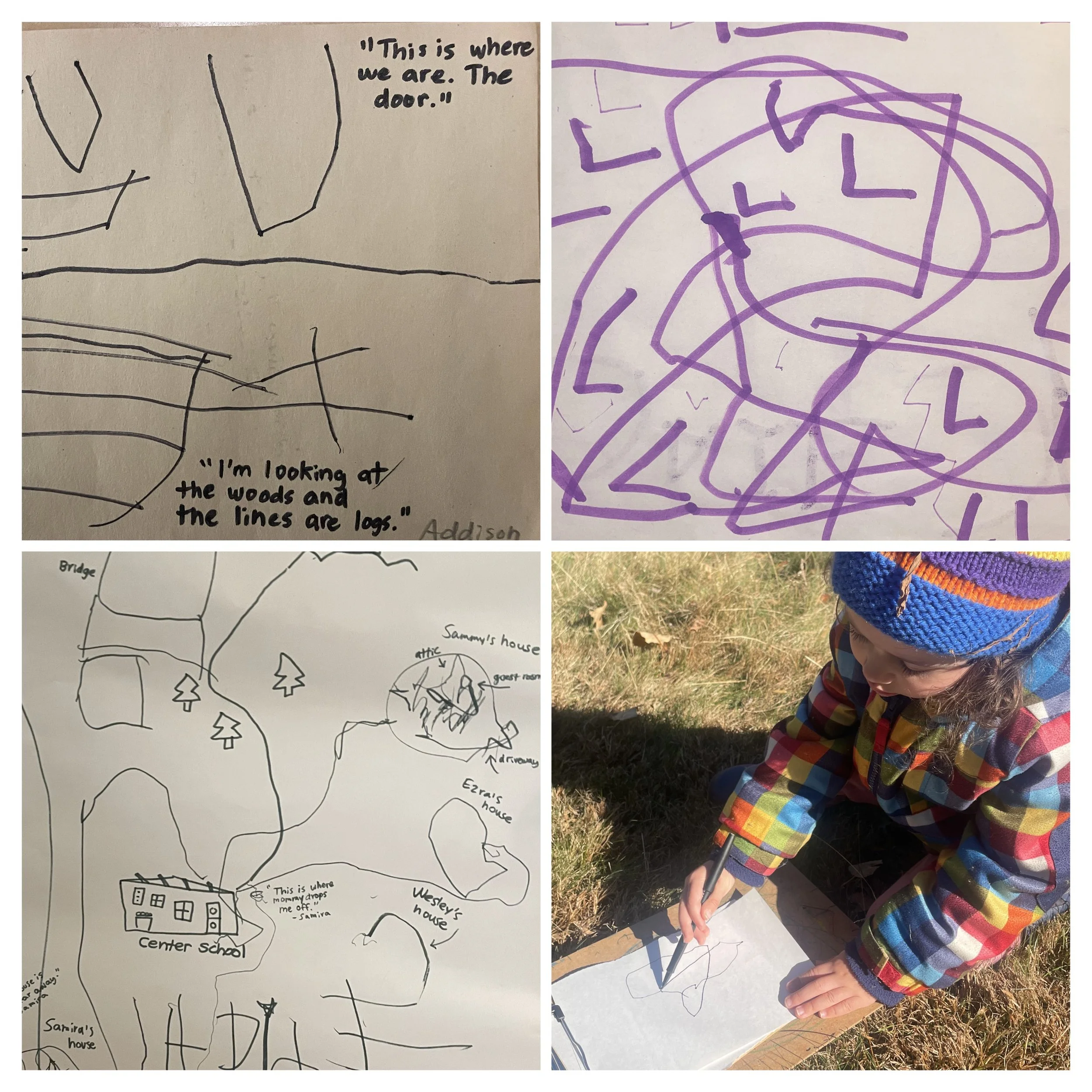
Lines on a page are not simply marks; they can represent paths, connect places, and communicate movement through space. We are beginning to explore how children use symbols, shapes, lines, and familiar landmarks to translate their experiences of a physical environment into a two-dimensional representation.
We also took these questions with us on a hike to Fairy Bog. Rather than simply following the familiar route, we invited the children to help us notice and remember important landmarks. What would someone need to know to find their way? Which turns, trees, bridges, and other features could help us recognize where we are?
Together, the children developed a set of directions to Fairy Bog:
Up Grasshopper Hill.
Ladder up to the top of the hill (and rock potty).
Right turn at the T.
The Factory.
Left turn at the fork in the trails.
Two bridges: one short and one long.
Right turn at the yellow blaze and pink flag.
Right turn at the Rainbow Arch.
Through Fairy Bog.
Exit the woods at the balance beam along the back field.
Sammy also offered an important piece of navigational advice:
Sammy: If we see the Mighty Mup Tree, we've gone too far!
We love how the children are beginning to use their shared knowledge of the landscape to develop a system for navigating it. They are thinking about direction, sequence, distance, and the relationship between recognizable landmarks. They are also beginning to consider how their knowledge might be communicated to someone who wasn't there with them.
As this investigation continues, we are curious to see how the children's maps evolve. Can they translate their drawings into a set of directions? Can someone else use their map to find the woods spot? What happens when we take a map outside and discover that something is missing, or that we need to add a new landmark?
Ultimately, we hope to give the children opportunities to design, test, revisit, and revise their maps, and eventually use them to take turns leading our hikes. What began with a simple wish to lead the way is becoming an exploration of how we understand, represent, and share our knowledge of the world around us.